Hydrogeological Surveys & Source Water Assessments

Hydrogeological Surveys and Source Water Assessments are systematic studies undertaken to evaluate groundwater resources, identify potential water sources, and determine their suitability, sustainability, and safety for various uses. These assessments combine geological, hydrological, and environmental investigations to ensure responsible water resource management.

Image

Hydrogeological Surveys

Hydrogeological surveys analyze subsurface conditions to understand the occurrence, movement, and quality of groundwater. Key components include:

  • Geological Mapping – Identifying rock types, soil layers, aquifers, and structural formations.
  • Aquifer Characterization – Determining aquifer depth, thickness, recharge rates, and storage capacity.
  • Groundwater Level Monitoring – Measuring seasonal and long-term fluctuations in water levels.
  • Geophysical Investigations – Using electrical resistivity, seismic, and electromagnetic methods to assess subsurface characteristics.
  • Pump Testing – Conducting step-drawdown and constant-rate pumping tests to evaluate well yield and aquifer performance.
  • Water Quality Analysis – Testing chemical, physical, and microbiological parameters to determine suitability for drinking, industrial, or irrigation use.

Purpose: To identify reliable groundwater sources, estimate their potential yield, and ensure sustainable extraction.

Source Water Assessments

Source water assessments evaluate the safety, vulnerability, and sustainability of existing or proposed water supply sources, including groundwater wells, springs, rivers, lakes, and reservoirs. Main activities include:

  • Source Identification – Locating and documenting available raw water sources.
  • Catchment Evaluation – Studying land use, recharge zones, hydrology, and environmental conditions.
  • Contamination Risk Assessment – Identifying natural and human-induced risks such as agriculture runoff, industrial discharge, septic systems, and geological hazards.
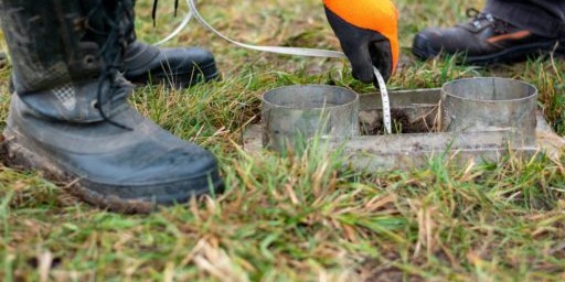
  • Water Quality Profiling – Conducting baseline and periodic water quality testing to assess long-term safety.
  • Quantity Assessment – Estimating safe yield, seasonal variations, drought resilience, and demand-supply balance.
  • Protection Zone Development – Recommending well-head protection areas and buffer zones to minimize contamination risks.

Purpose: To ensure the selected source is safe, sustainable, and capable of meeting current and future water demand.

Soil Infiltration Tests

Soil infiltration tests are conducted to determine the rate at which water enters and moves through the soil. This assessment is essential in understanding soil permeability, drainage capacity, and its suitability for applications such as:
  • Groundwater recharge projects – to evaluate how effectively water can percolate into aquifers.
  • Sewage and effluent disposal systems – to check soil absorption capacity for soak pits, leach fields, or constructed wetlands.
  • Rainwater harvesting systems – to design recharge wells or percolation pits.
  • Civil engineering and construction projects – to assess stormwater management and flood control feasibility.